Reading FEMA FIRM Panels for Development Projects
How to find and read the flood zone data that drives permit requirements.

- Written by
- Tomás IbargüenStaff Writer, Environmental Systems
- Published
- October 10, 2026
- Reading time
- 11 min read
- Sources cited
- 7 sources ↓
What this covers
A Flood Insurance Rate Map is the official document FEMA produces to delineate flood hazard areas and set the minimum regulatory requirements for the National Flood Insurance Program.
FEMA builds each FIRM on an underlying engineering study called a Flood Insurance Study. The map and the study are companion documents, and neither substitutes for the other: the FIRM shows where the hazard sits on the ground, while the FIS carries the hydraulic modeling, the cross-section data, and the water surface profiles that justify the lines drawn on the map. The FIRM's central output is the delineation of Special Flood Hazard Areas, the mapped floodplains that trigger mandatory flood insurance purchase requirements and set minimum floodplain management standards for construction. In practice, a project team will encounter the map in two formats: the full FIRM panel, which covers an entire jurisdiction, and the FIRMette, a smaller, printable excerpt covering a specific area of interest. You can access both through FEMA's NFHL Viewer and Map Service Center, and both carry the same regulatory weight once they're effective.
How to locate the correct panel for a site
Before any zone designation, elevation requirement, or floodway line can be read correctly, a project team has to confirm it is looking at the right panel for the right jurisdiction, pulled from an authoritative source rather than a third-party viewer or a saved image of unknown vintage. FEMA's Map Service Center and its NFHL Viewer are the starting points: a user enters an address or navigates the map directly to the site, then downloads or prints the FIRM or FIRMette covering that location.
The NFHL digital database behind these tools covers more than 90% of the U.S. population and is updated continuously as new or revised data becomes effective, which in most cases makes it a more current source than a static paper panel pulled from a file drawer or an old PDF. Teams working in GIS environments can pull county- or state-level NFHL data directly in shapefile format through the Map Service Center's "Search All Products" function, or bring it into Google Earth as a KMZ overlay for quick visual review alongside a site plan. FEMA's own guidance confirms that the NFHL can stand in for the printed FIRM for NFIP purposes, so long as the data shown is effective. State-level portals, such as Georgia's FIRM/FIS Search or Louisiana's LA Floodmaps viewer, aggregate effective FIRM data at the county and community level and can speed up an initial lookup considerably. Even so, you should check the effective date and panel status pulled from a state portal against the Map Service Center before you rely on it for a permitting decision.
How FIRM Panel Numbers Are Structured
Once the right general area has been located, the panel itself needs to be verified by its identifier, not just its appearance on screen. Every FIRM panel carries an alphanumeric identifier that encodes the community, the panel index, and the map's revision status, and a team that misreads any one of those segments ends up working from the wrong geography or from an edition FEMA has already superseded.
The community identifier ties the panel to a specific jurisdiction, so even when two towns or counties sit side by side geographically, their panels will carry entirely different leading digits. The panel number that follows identifies which section of that jurisdiction's floodplain the sheet covers, and jurisdictions with complex floodplain geography can run to dozens of panels across a single county. A suffix letter closes out the identifier and marks the revision status of that particular sheet, distinguishing a current edition from one that has since been revised or replaced. A panel index map, often printed as a separate sheet in the full FIRM set, shows which panel number covers which part of the jurisdiction, and checking that index first is what prevents a team from pulling the panel for an adjacent area that happens to carry a similar number. None of this is complicated once a reader has gone through it a single time, but it rewards recognition over memorization: the point is to know what each segment of the identifier is telling you, not to carry the format in your head.
What the flood zone designations on the map actually mean for a project
Once the correct panel is confirmed, the single most consequential piece of information it carries is the zone designation shown at the site's location: it sets whether federal flood insurance is mandatory, what elevation standards apply, and what the permitting path will look like from that point forward. Special Flood Hazard Areas, marked with an A or V prefix, represent land with a one-in-a-hundred annual chance of flooding, the flood commonly referred to as the "100-year flood," and any parcel falling inside one carries the mandatory insurance purchase requirement along with the strictest development standards FEMA imposes. Zone AE is the most common SFHA category among detailed-study areas, with a Base Flood Elevation established and published either directly on the map or in the accompanying FIS. Zone A, when it appears without a number, marks an SFHA where no BFE has been determined through detailed engineering study, which leaves the site in a more uncertain and often more complicated position for design purposes. Zone AO covers shallow flooding driven by sheet flow, and instead of a BFE it carries a flood depth figure that does a similar job. Zone VE identifies a coastal high-hazard area where wave action is a factor, and it carries additional freeboard and structural requirements layered on top of what Zone AE already demands.
The distinction between a detailed-study zone and an approximate zone shapes how a project moves forward from the moment the zone is identified. Detailed zones such as AE and VE come with mapped BFEs and, frequently, mapped floodways already established by FEMA's hydraulic modeling. Approximate zones, the unnumbered A designation chief among them, leave that work undone, and the engineer or developer has to commission additional study to establish elevations before permitting can proceed. That difference alone can add months and real engineering cost to a project timeline, so you need to confirm the zone designation early, before site layout or financing assumptions are locked in, just as much as the panel itself.
Reading the Base Flood Elevation and understanding what it requires of a structure
The Base Flood Elevation is the water surface elevation that the one-in-a-hundred annual chance flood is expected to reach at a given location, and for any site inside an SFHA, every finished floor, every foundation decision, every mechanical system, and every stormwater detention calculation has to be measured against that number. It is the design datum the rest of the project organizes itself around once a zone with a BFE has been confirmed.
The BFE shown on the FIRM is the output of the hydraulic modeling published in the companion FIS report, where the cross-section data and water surface profiles live, and reading the BFE off the map without going to the FIS profile tables leaves out the engineering that supports it. Lowest floor elevation requirements translate that single number into construction standards that vary by zone. In Zone AE, the typical federal minimum places the lowest floor at or above the BFE, and many local ordinances go further and require one or two feet of additional freeboard above that federal floor. In Zone VE, the standard changes in kind rather than degree: construction has to be elevated on open foundations, piles or columns, with the bottom of the lowest horizontal structural member set at or above the BFE. If a project site straddles two BFE contours or falls between labeled cross-sections on the map, you can't just read the design BFE off the nearest line. It has to be interpolated from the FIS profile data, and that interpolation is the responsibility of the licensed engineer of record, who is accountable for establishing the correct design elevation for that specific parcel.
Cross-Sections and Floodways on the FIRM
Knowing how high a flood will reach is only half the picture. The FIRM also shows where floodwater moves fastest and with the greatest force, through the floodway, which appears on the map as a cross-hatched band running within the broader SFHA. The floodway is the conveyance channel of the flood, the zone where velocity and depth combine to make development most hazardous, and FEMA regulates it accordingly as the most restricted portion of the mapped floodplain. The flood fringe, by contrast, is the area between the floodway's edge and the outer boundary of the SFHA, and filling or building there is permitted, but only if a No-Rise analysis demonstrates that the proposed work will not increase the BFE upstream, or if a LOMA or LOMR of appropriate scope has already addressed the change.
Cross-section lines on the FIRM, typically labeled with paired letters, mark the specific transects where FEMA's hydraulic model computed water surface elevations for the FIS. Those lines correspond directly to profile tables in the study, and a site engineer reads the FIS table at the cross-section nearest the project to extract the governing BFE for that stretch of the floodplain. For a site that sits partially inside the floodway and partially in the flood fringe, the project layout has to be organized around the floodway line as a hard constraint. Even minor encroachment into the floodway triggers the No-Rise requirement, and failing to account for that can invalidate a site plan that was otherwise ready to move to permitting.
Letters of Map Change
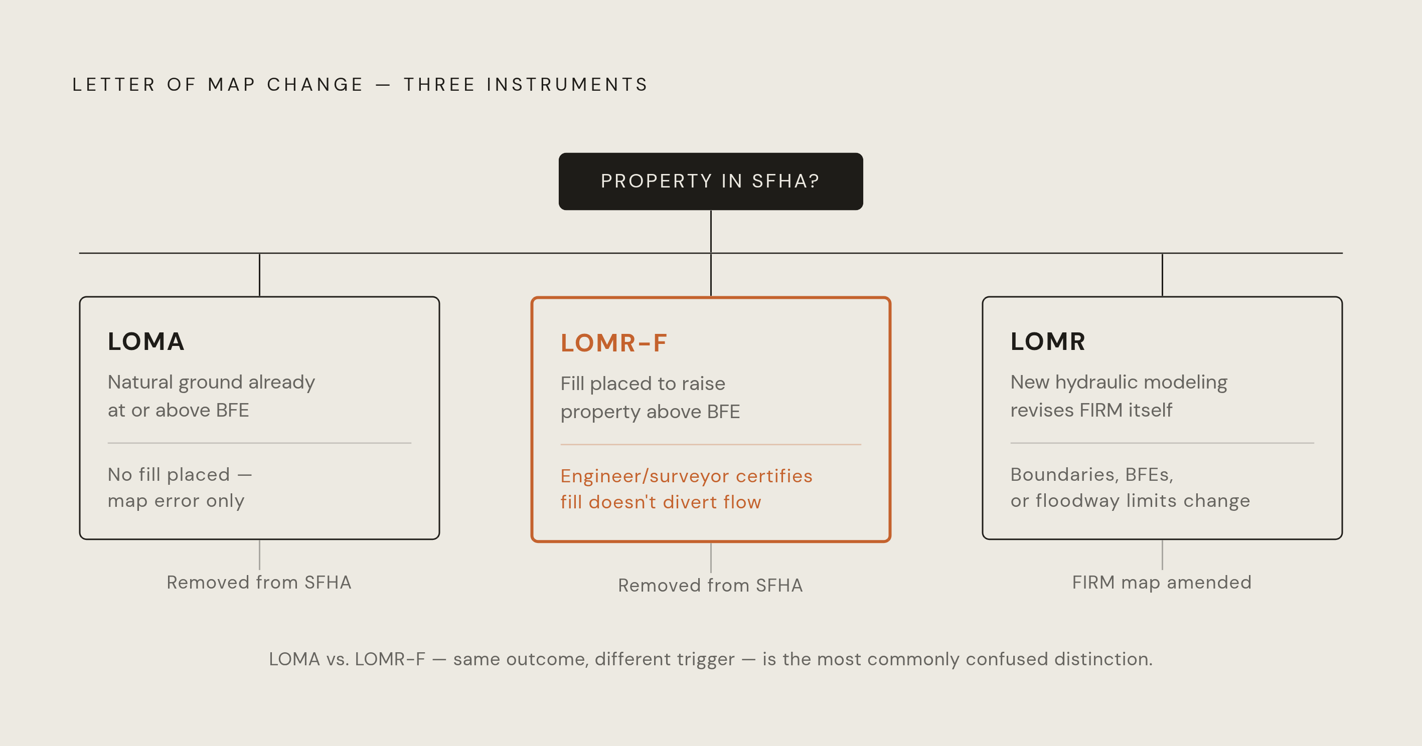
A FIRM is accurate until it isn't, and when a surveyed site elevation or a completed fill project places a structure or parcel above the BFE or outside the mapped SFHA entirely, the map itself hasn't caught up to that reality. A Letter of Map Change is FEMA's formal mechanism for correcting the record for that specific property, and obtaining one can remove or reduce the mandatory flood insurance requirement while shifting the permitting baseline the project works from.
FEMA's LOMC process covers three distinct instruments, and development teams often mix up the first two. A Letter of Map Amendment applies when a property's natural ground elevation, confirmed by a licensed land surveyor, is already at or above the BFE: no fill was ever placed, and the map simply failed to reflect the actual terrain. A Letter of Map Revision Based on Fill applies to the opposite situation, where fill has been placed on the property specifically to elevate it above the BFE, and a licensed engineer or surveyor must document that fill and certify that it does not divert floodwaters onto neighboring parcels. A Letter of Map Revision is broader still, changing the FIRM itself (its boundaries, its BFEs, its floodway limits) typically on the strength of new or revised hydraulic modeling, and it's the instrument that follows a major infrastructure project, a channel modification, or a detention facility shown to reduce flood risk. FEMA folds effective LOMCs into the NFHL database as they take effect, so the NFHL can reflect a different zone for a parcel than the printed FIRM panel underneath it still shows. Lee County, Florida offers a concrete illustration of how a map revision cycle generates LOMC opportunities in bulk: owners whose property sits above the new BFE established by the 2026 remapping may qualify for a LOMA shortly after the March 2, 2027 effective date. A single revision cycle can open a window for a wave of affected property owners at once.
Tracking Map Revision Cycles
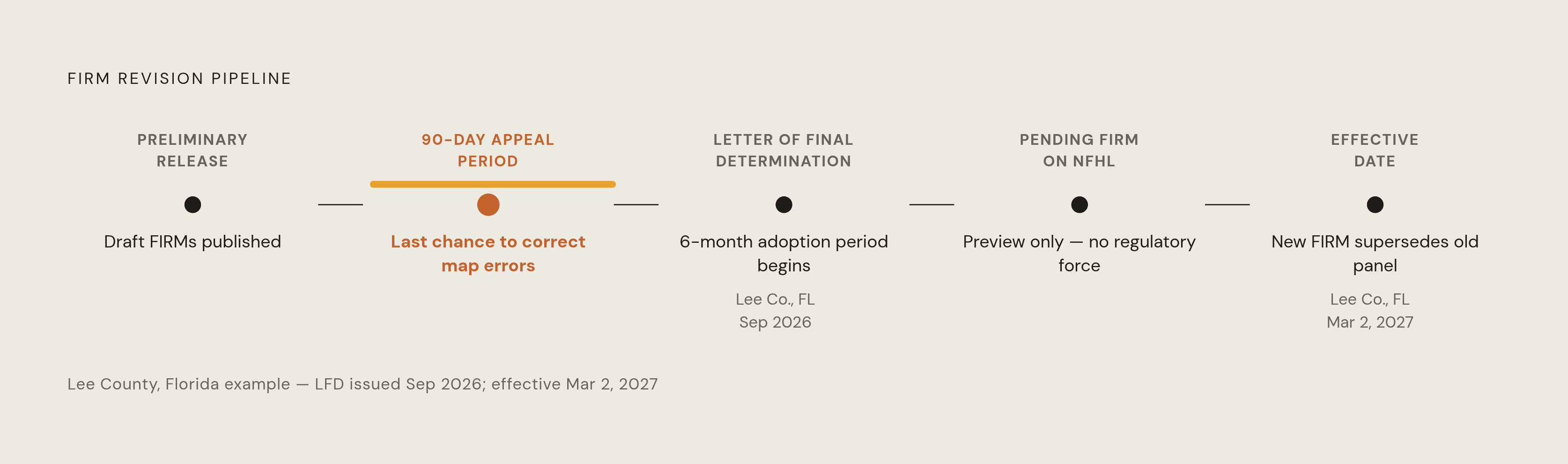
A FIRM read correctly today can still be overtaken by a revision already moving through FEMA's pipeline, so if a project team treats its site analysis as settled once the panel has been read, it has skipped a step. The revision pipeline runs through distinct, formal stages, and those stages give a project team a predictable window in which to respond before anything becomes binding.
The cycle opens with a preliminary release, when draft FIRMs and the accompanying FIS are published for public review. A project team should examine preliminary maps as soon as they appear, because they show what the regulatory baseline will become even before it takes effect. A 90-day comment and appeal period follows, and it is the only stage at which a map error can still be corrected with revised engineering analysis before the determination becomes final. FEMA then issues a Letter of Final Determination to the community's chief executive, confirming that the new maps will become effective, and that letter starts a six-month adoption and compliance period during which the community has to update its floodplain ordinances to match. Pending FIRM databases become available on the NFHL roughly six months ahead of the effective date; they don't yet govern NFIP requirements, but lenders, developers, and local officials can use them to prepare for what's coming. On the effective date itself, the new FIRM becomes the regulatory baseline and the old panel is superseded.
FEMA's Preliminary Flood Hazard Data tool centralizes nationwide preliminary FIRM, FIS, and FIRM database downloads, and it's the practical first stop for checking whether a given jurisdiction has an active preliminary revision underway. The Flood Map Changes Viewer lets you compare preliminary or pending changes against the current effective data for a community, and the Preliminary Map Comparison Tool offers side-by-side comparison of preliminary data specifically, so it's the most direct way to check whether a particular parcel sits inside an in-progress revision. Lee County, Florida's revised panels, covering six panels in unincorporated Lee County tied to the Mullock Creek floodway, carry a Letter of Final Determination issued September 2026 and an effective date of March 2, 2027, giving the development community there a defined runway to adjust site plans, pursue LOMCs, or revise financing assumptions before the new map takes over as the governing document. A team that checks the pipeline at the preliminary stage keeps its options open: it can still appeal, still adjust a site design, still revise a pro forma before anything is locked in. A team that finds out about a revision only after it has gone effective is left choosing among redesign, re-permitting, and insurance reclassification, none of which are cheap, and none of which were necessary if the pipeline had been watched from the start.
Methodology & sources
- Flood Data Viewers and Geospatial Data
Provided details on the NFHL database coverage, its use as a substitute for printed FIRMs, and its data access options including shapefiles and KMZ overlays.
- Risk MAP Projects
Provided details on the 90-day comment and appeal period in the FIRM revision cycle.
- Preliminary Flood Hazard Data - Mapping Information Platform
Identified as the centralized tool for downloading preliminary FIRM, FIS, and FIRM database files nationwide.
- LA Floodmaps
Cited as an example of a state-level portal that aggregates effective FIRM data for faster initial lookups.
- Floodplain Mapping
Sourced details on the LOMC process distinctions and the six-month adoption and compliance period following a Letter of Final Determination.
- FIRM/FIS Search
Cited as an example of a state-level portal for aggregating effective FIRM data at the county and community level.
- How to Read a Flood Map January 2022
Informed the explanations of FIRM panel structure, zone designations, BFE interpretation, and floodway reading throughout the article.